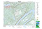
Maps showing Steady Brook, Humber East, Newfoundland and Labrador
Steady Brook is a Town located in Humber East, Newfoundland and Labrador and has an elevation of 54 meters.
- Latitude: 48° 57' 30'' North (decimal: 48.9583944)
- Longitude: 57° 49' 6'' West (decimal: -57.8184527)
- Topography Feature Category: Town
- Geographical Feature: Town
- Canadian Province/Territory: Newfoundland and Labrador
- Elevation: 54 meters
- Location: Humber East
- Atlas of Canada Locator Map: Steady Brook
- GPS Coordinate Locator Map: Steady Brook Lat/Long
Steady Brook NTS Map Sheets