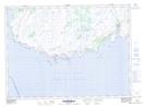
Maps showing Blow Hole Rock, Newfoundland and Labrador
Blow Hole Rock is a Shoal located in Newfoundland and Labrador.
- Latitude: 46° 51' 53'' North (decimal: 46.8647222)
- Longitude: 55° 46' 51'' West (decimal: -55.7808333)
- Topography Feature Category: Shoal
- Geographical Feature: Rock
- Canadian Province/Territory: Newfoundland and Labrador
- Atlas of Canada Locator Map: Blow Hole Rock
- GPS Coordinate Locator Map: Blow Hole Rock Lat/Long
Blow Hole Rock NTS Map Sheets