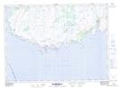
Maps showing Point Crewe, Newfoundland and Labrador
Point Crewe is a Unincorporated area located in Newfoundland and Labrador.
- Latitude: 46° 55' 00'' North (decimal: 46.9166666)
- Longitude: 55° 57' 57'' West (decimal: -55.9658333)
- Topography Feature Category: Unincorporated area
- Geographical Feature: Vacated or Seasonal Settlement
- Canadian Province/Territory: Newfoundland and Labrador
- Atlas of Canada Locator Map: Point Crewe
- GPS Coordinate Locator Map: Point Crewe Lat/Long
Point Crewe NTS Map Sheets