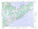
Maps showing Seal Island Bight, Newfoundland and Labrador
Seal Island Bight is a Bay located in Newfoundland and Labrador and has an elevation of 29 meters.
- Latitude: 49° 59' 00'' North (decimal: 49.9833333)
- Longitude: 55° 29' 38'' West (decimal: -55.4938888)
- Topography Feature Category: Bay
- Geographical Feature: Bight
- Canadian Province/Territory: Newfoundland and Labrador
- Elevation: 29 meters
- Atlas of Canada Locator Map: Seal Island Bight
- GPS Coordinate Locator Map: Seal Island Bight Lat/Long
Seal Island Bight NTS Map Sheets