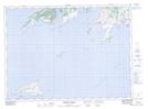
Maps showing Hell Hole Shoal, Newfoundland and Labrador
Hell Hole Shoal is a Shoal located in Newfoundland and Labrador.
- Latitude: 47° 27' 50'' North (decimal: 47.4638888)
- Longitude: 55° 39' 42'' West (decimal: -55.6616666)
- Topography Feature Category: Shoal
- Geographical Feature: Shoal
- Canadian Province/Territory: Newfoundland and Labrador
- Atlas of Canada Locator Map: Hell Hole Shoal
- GPS Coordinate Locator Map: Hell Hole Shoal Lat/Long
Hell Hole Shoal NTS Map Sheets