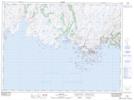
Maps showing Galloping Moll, Newfoundland and Labrador
Galloping Moll is a Shoal located in Newfoundland and Labrador.
- Latitude: 47° 36' 11'' North (decimal: 47.6031533)
- Longitude: 57° 41' 24'' West (decimal: -57.6898983)
- Topography Feature Category: Shoal
- Geographical Feature: Rock
- Canadian Province/Territory: Newfoundland and Labrador
- Atlas of Canada Locator Map: Galloping Moll
- GPS Coordinate Locator Map: Galloping Moll Lat/Long