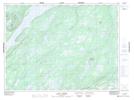
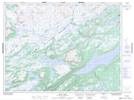
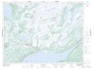
Maps showing Red Indian Lake, Newfoundland and Labrador
Red Indian Lake is a Lake located in Newfoundland and Labrador and has an elevation of 165 meters.
- Latitude: 48° 44' 21'' North (decimal: 48.7391911)
- Longitude: 56° 50' 47'' West (decimal: -56.8463352)
- Topography Feature Category: Lake
- Geographical Feature: Lake
- Canadian Province/Territory: Newfoundland and Labrador
- Elevation: 165 meters
- Atlas of Canada Locator Map: Red Indian Lake
- GPS Coordinate Locator Map: Red Indian Lake Lat/Long
Red Indian Lake NTS Map Sheets