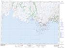
Maps showing Sandbanks Provincial Park, Burgeo-Bay d'Espoir, Newfoundland and Labrador
Sandbanks Provincial Park is a Conservation area located in Burgeo-Bay d'Espoir, Newfoundland and Labrador and has an elevation of 7 meters.
- Latitude: 47° 36' 26'' North (decimal: 47.6072222)
- Longitude: 57° 38' 50'' West (decimal: -57.6472222)
- Topography Feature Category: Conservation area
- Geographical Feature: Provincial Park
- Canadian Province/Territory: Newfoundland and Labrador
- Elevation: 7 meters
- Location: Burgeo-Bay d'Espoir
- Atlas of Canada Locator Map: Sandbanks Provincial Park
- GPS Coordinate Locator Map: Sandbanks Provincial Park Lat/Long