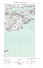
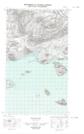
Maps showing Pompeys Leg, Torngat Mountains, Newfoundland and Labrador
Pompeys Leg is a Cape located in Torngat Mountains, Newfoundland and Labrador.
- Latitude: 54° 18' 55'' North (decimal: 54.3152408)
- Longitude: 57° 58' 39'' West (decimal: -57.9775728)
- Topography Feature Category: Cape
- Geographical Feature: Point
- Canadian Province/Territory: Newfoundland and Labrador
- Location: Torngat Mountains
- Atlas of Canada Locator Map: Pompeys Leg
- GPS Coordinate Locator Map: Pompeys Leg Lat/Long
Pompeys Leg NTS Map Sheets