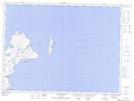
Maps showing Monday Pond Marsh, Trinity-Bay de Verde, Newfoundland and Labrador
Monday Pond Marsh is a Low vegetation located in Trinity-Bay de Verde, Newfoundland and Labrador.
- Latitude: 48° 4' 7'' North (decimal: 48.0686111)
- Longitude: 52° 58' 38'' West (decimal: -52.9772222)
- Topography Feature Category: Low vegetation
- Geographical Feature: Marsh
- Canadian Province/Territory: Newfoundland and Labrador
- Location: Trinity-Bay de Verde
- Atlas of Canada Locator Map: Monday Pond Marsh
- GPS Coordinate Locator Map: Monday Pond Marsh Lat/Long
Monday Pond Marsh NTS Map Sheets