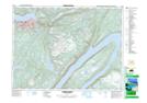
Maps showing Maple Valley Industrial Park, Bay of Islands, Newfoundland and Labrador
Maple Valley Industrial Park is a Unincorporated area located in Bay of Islands, Newfoundland and Labrador and has an elevation of 133 meters.
- Latitude: 48° 57' 00'' North (decimal: 48.9499999)
- Longitude: 57° 55' 1'' West (decimal: -57.9169444)
- Topography Feature Category: Unincorporated area
- Geographical Feature: Industrial Park
- Canadian Province/Territory: Newfoundland and Labrador
- Elevation: 133 meters
- Location: Bay of Islands
- Atlas of Canada Locator Map: Maple Valley Industrial Park
- GPS Coordinate Locator Map: Maple Valley Industrial Park Lat/Long
Maple Valley Industrial Park NTS Map Sheets