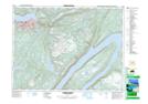
Maps showing The Old Man, Humber Valley, Newfoundland and Labrador
The Old Man is a Mountain located in Humber Valley, Newfoundland and Labrador and has an elevation of 233 meters.
- Latitude: 48° 57' 2'' North (decimal: 48.9505555)
- Longitude: 57° 51' 57'' West (decimal: -57.8658333)
- Topography Feature Category: Mountain
- Geographical Feature: Hill
- Canadian Province/Territory: Newfoundland and Labrador
- Elevation: 233 meters
- Location: Humber Valley
- Atlas of Canada Locator Map: The Old Man
- GPS Coordinate Locator Map: The Old Man Lat/Long
The Old Man NTS Map Sheets