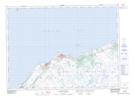
Maps showing Wet Tilt Ridge, Grand Bank, Newfoundland and Labrador
Wet Tilt Ridge is a Mountain located in Grand Bank, Newfoundland and Labrador.
- Latitude: 47° 1' 14'' North (decimal: 47.0205555)
- Longitude: 55° 30' 37'' West (decimal: -55.5102777)
- Topography Feature Category: Mountain
- Geographical Feature: Ridge
- Canadian Province/Territory: Newfoundland and Labrador
- Location: Grand Bank
- Atlas of Canada Locator Map: Wet Tilt Ridge
- GPS Coordinate Locator Map: Wet Tilt Ridge Lat/Long
Wet Tilt Ridge NTS Map Sheets