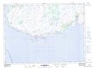
Maps showing Sandy Cove Island Pond, Grand Bank, Newfoundland and Labrador
Sandy Cove Island Pond is a Lake located in Grand Bank, Newfoundland and Labrador.
- Latitude: 46° 55' 34'' North (decimal: 46.9261111)
- Longitude: 55° 38' 27'' West (decimal: -55.6408333)
- Topography Feature Category: Lake
- Geographical Feature: Pond
- Canadian Province/Territory: Newfoundland and Labrador
- Location: Grand Bank
- Atlas of Canada Locator Map: Sandy Cove Island Pond
- GPS Coordinate Locator Map: Sandy Cove Island Pond Lat/Long
Sandy Cove Island Pond NTS Map Sheets