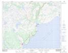
Maps showing The Battery, Newfoundland and Labrador
The Battery is a Mountain located in Newfoundland and Labrador.
- Latitude: 51° 33' 59'' North (decimal: 51.5662600)
- Longitude: 56° 49' 16'' West (decimal: -56.8211299)
- Topography Feature Category: Mountain
- Geographical Feature: Hill
- Canadian Province/Territory: Newfoundland and Labrador
- Atlas of Canada Locator Map: The Battery
- GPS Coordinate Locator Map: The Battery Lat/Long
The Battery NTS Map Sheets