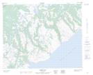
Maps showing Juniper Pond, Newfoundland and Labrador
Juniper Pond is a Lake located in Newfoundland and Labrador.
- Latitude: 51° 46' 21'' North (decimal: 51.7725600)
- Longitude: 56° 25' 2'' West (decimal: -56.4172998)
- Topography Feature Category: Lake
- Geographical Feature: Pond
- Canadian Province/Territory: Newfoundland and Labrador
- Atlas of Canada Locator Map: Juniper Pond
- GPS Coordinate Locator Map: Juniper Pond Lat/Long
Juniper Pond NTS Map Sheets