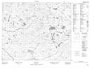
Maps showing Southwest Feeder, Newfoundland and Labrador
Southwest Feeder is a River located in Newfoundland and Labrador.
- Latitude: 53° 3' 30'' North (decimal: 53.0584100)
- Longitude: 57° 31' 37'' West (decimal: -57.5268699)
- Topography Feature Category: River
- Geographical Feature: Brook
- Canadian Province/Territory: Newfoundland and Labrador
- Atlas of Canada Locator Map: Southwest Feeder
- GPS Coordinate Locator Map: Southwest Feeder Lat/Long
Southwest Feeder NTS Map Sheets