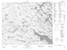
Maps showing Rolands Pond, Newfoundland and Labrador
Rolands Pond is a Lake located in Newfoundland and Labrador.
- Latitude: 52° 48' 5'' North (decimal: 52.8015000)
- Longitude: 56° 19' 49'' West (decimal: -56.3301699)
- Topography Feature Category: Lake
- Geographical Feature: Pond
- Canadian Province/Territory: Newfoundland and Labrador
- Atlas of Canada Locator Map: Rolands Pond
- GPS Coordinate Locator Map: Rolands Pond Lat/Long
Rolands Pond NTS Map Sheets