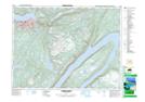
Maps showing Glover Island Public Reserve, Newfoundland and Labrador
Glover Island Public Reserve is a Conservation area located in Newfoundland and Labrador.
- Latitude: 48° 46' 52'' North (decimal: 48.781111)
- Longitude: 57° 42' 3'' West (decimal: -57.7008333)
- Topography Feature Category: Conservation area
- Geographical Feature: Crown Lands Reserve
- Canadian Province/Territory: Newfoundland and Labrador
- Atlas of Canada Locator Map: Glover Island Public Reserve
- GPS Coordinate Locator Map: Glover Island Public Reserve Lat/Long
Glover Island Public Reserve NTS Map Sheets