Maps showing Burnt Hill, Newfoundland and Labrador
Burnt Hill is a Mountain located in Newfoundland and Labrador.
- Latitude: 47° 50' 23'' North (decimal: 47.8396298)
- Longitude: 57° 8' 10'' West (decimal: -57.1360799)
- Topography Feature Category: Mountain
- Geographical Feature: Hill
- Canadian Province/Territory: Newfoundland and Labrador
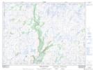
- Atlas of Canada Locator Map: Burnt Hill
- GPS Coordinate Locator Map: Burnt Hill Lat/Long
Burnt Hill NTS Map Sheets