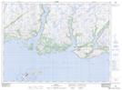
Maps showing Pinks Point Isle, Newfoundland and Labrador
Pinks Point Isle is a Island located in Newfoundland and Labrador.
- Latitude: 47° 31' 13'' North (decimal: 47.5203599)
- Longitude: 57° 20' 56'' West (decimal: -57.3489298)
- Topography Feature Category: Island
- Geographical Feature: Isle
- Canadian Province/Territory: Newfoundland and Labrador
- Atlas of Canada Locator Map: Pinks Point Isle
- GPS Coordinate Locator Map: Pinks Point Isle Lat/Long