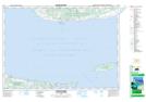
Maps showing Indian Rocks, Queens, Prince Edward Island
Indian Rocks is a Shoal located in Queens, Prince Edward Island.
- Latitude: 45° 56' North (decimal: 45.9333000)
- Longitude: 62° 49' West (decimal: -62.8166999)
- Topography Feature Category: Shoal
- Geographical Feature: Rocks
- Canadian Province/Territory: Prince Edward Island
- Location: Queens
- Atlas of Canada Locator Map: Indian Rocks
- GPS Coordinate Locator Map: Indian Rocks Lat/Long
Indian Rocks NTS Map Sheets