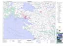
Maps showing Port Borden, Prince, Prince Edward Island
Port Borden is a Unincorporated area located in Prince, Prince Edward Island.
- Latitude: 46° 15' 10'' North (decimal: 46.2528000)
- Longitude: 63° 41' 55'' West (decimal: -63.6986000)
- Topography Feature Category: Unincorporated area
- Geographical Feature: Post Office
- Canadian Province/Territory: Prince Edward Island
- Location: Prince
- Atlas of Canada Locator Map: Port Borden
- GPS Coordinate Locator Map: Port Borden Lat/Long
Port Borden NTS Map Sheets