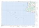
Maps showing Cap Egmont, Prince, Prince Edward Island
Cap Egmont is a Cape located in Prince, Prince Edward Island.
- Latitude: 46° 24' 6'' North (decimal: 46.4016668)
- Longitude: 64° 8' 4'' West (decimal: -64.1344438)
- Topography Feature Category: Cape
- Geographical Feature: Cap
- Canadian Province/Territory: Prince Edward Island
- Location: Prince
- Atlas of Canada Locator Map: Cap Egmont
- GPS Coordinate Locator Map: Cap Egmont Lat/Long
Cap Egmont NTS Map Sheets