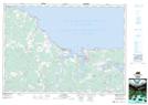
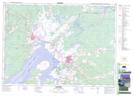
Maps showing Amherst Head, Cumberland, Nova Scotia
Amherst Head is a Unincorporated area located in Cumberland, Nova Scotia and has an elevation of 60 meters.
- Latitude: 45° 53' 19'' North (decimal: 45.8886111)
- Longitude: 63° 59' 25'' West (decimal: -63.9902777)
- Topography Feature Category: Unincorporated area
- Geographical Feature: Community
- Canadian Province/Territory: Nova Scotia
- Elevation: 60 meters
- Location: Cumberland
- Atlas of Canada Locator Map: Amherst Head
- GPS Coordinate Locator Map: Amherst Head Lat/Long
Amherst Head NTS Map Sheets