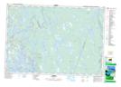
Maps showing The Bar, Yarmouth, Nova Scotia
The Bar is a Channel located in Yarmouth, Nova Scotia and has an elevation of 2 meters.
- Latitude: 43° 49' North (decimal: 43.8166666)
- Longitude: 65° 52' West (decimal: -65.8658333)
- Topography Feature Category: Channel
- Geographical Feature: Channel
- Canadian Province/Territory: Nova Scotia
- Elevation: 2 meters
- Location: Yarmouth
- Atlas of Canada Locator Map: The Bar
- GPS Coordinate Locator Map: The Bar Lat/Long