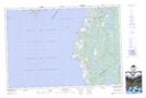
Maps showing Cedar Lake, Digby; Yarmouth, Nova Scotia
Cedar Lake is a Unincorporated area located in Digby; Yarmouth, Nova Scotia and has an elevation of 13 meters.
- Latitude: 44° 2' 22'' North (decimal: 44.0394443)
- Longitude: 66° 6' 17'' West (decimal: -66.1047221)
- Topography Feature Category: Unincorporated area
- Geographical Feature: Community
- Canadian Province/Territory: Nova Scotia
- Elevation: 13 meters
- Location: Digby; Yarmouth
- Atlas of Canada Locator Map: Cedar Lake
- GPS Coordinate Locator Map: Cedar Lake Lat/Long