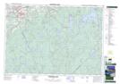
Maps showing County Line Lake, Kings, Nova Scotia
County Line Lake is a Lake located in Kings, Nova Scotia and has an elevation of 175 meters.
- Latitude: 44° 45' 36'' North (decimal: 44.7599999)
- Longitude: 64° 39' 49'' West (decimal: -64.6636111)
- Topography Feature Category: Lake
- Geographical Feature: Lake
- Canadian Province/Territory: Nova Scotia
- Elevation: 175 meters
- Location: Kings
- Atlas of Canada Locator Map: County Line Lake
- GPS Coordinate Locator Map: County Line Lake Lat/Long
County Line Lake NTS Map Sheets