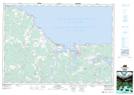
Maps showing East Leicester, Cumberland, Nova Scotia
East Leicester is a Unincorporated area located in Cumberland, Nova Scotia and has an elevation of 105 meters.
- Latitude: 45° 47' 46'' North (decimal: 45.7961111)
- Longitude: 63° 58' 19'' West (decimal: -63.9719444)
- Topography Feature Category: Unincorporated area
- Geographical Feature: Community
- Canadian Province/Territory: Nova Scotia
- Elevation: 105 meters
- Location: Cumberland
- Atlas of Canada Locator Map: East Leicester
- GPS Coordinate Locator Map: East Leicester Lat/Long