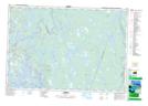
Maps showing Frosts Pond, Yarmouth, Nova Scotia
Frosts Pond is a Lake located in Yarmouth, Nova Scotia and has an elevation of 16 meters.
- Latitude: 43° 47' 56'' North (decimal: 43.7988888)
- Longitude: 65° 50' 51'' West (decimal: -65.8475000)
- Topography Feature Category: Lake
- Geographical Feature: Pond
- Canadian Province/Territory: Nova Scotia
- Elevation: 16 meters
- Location: Yarmouth
- Atlas of Canada Locator Map: Frosts Pond
- GPS Coordinate Locator Map: Frosts Pond Lat/Long