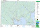
Maps showing Glengarry, Lunenburg, Nova Scotia
Glengarry is a Unincorporated area located in Lunenburg, Nova Scotia and has an elevation of 131 meters.
- Latitude: 44° 42' 20'' North (decimal: 44.7055555)
- Longitude: 64° 27' 25'' West (decimal: -64.4569444)
- Topography Feature Category: Unincorporated area
- Geographical Feature: Locality
- Canadian Province/Territory: Nova Scotia
- Elevation: 131 meters
- Location: Lunenburg
- Atlas of Canada Locator Map: Glengarry
- GPS Coordinate Locator Map: Glengarry Lat/Long
Glengarry NTS Map Sheets