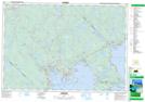
Maps showing Joe Bill Pond, Lunenburg, Nova Scotia
Joe Bill Pond is a Lake located in Lunenburg, Nova Scotia and has an elevation of 121 meters.
- Latitude: 44° 39' 12'' North (decimal: 44.6533333)
- Longitude: 64° 24' 27'' West (decimal: -64.4075000)
- Topography Feature Category: Lake
- Geographical Feature: Pond
- Canadian Province/Territory: Nova Scotia
- Elevation: 121 meters
- Location: Lunenburg
- Atlas of Canada Locator Map: Joe Bill Pond
- GPS Coordinate Locator Map: Joe Bill Pond Lat/Long
Joe Bill Pond NTS Map Sheets