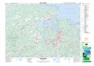
Maps showing Logan Subdivision, Pictou, Nova Scotia
Logan Subdivision is a Unincorporated area located in Pictou, Nova Scotia and has an elevation of 42 meters.
- Latitude: 45° 37' 7'' North (decimal: 45.6186111)
- Longitude: 62° 37' 39'' West (decimal: -62.6275000)
- Topography Feature Category: Unincorporated area
- Geographical Feature: Neighbourhood
- Canadian Province/Territory: Nova Scotia
- Elevation: 42 meters
- Location: Pictou
- Atlas of Canada Locator Map: Logan Subdivision
- GPS Coordinate Locator Map: Logan Subdivision Lat/Long