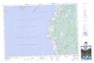
Maps showing Maxwellton, Digby, Nova Scotia
Maxwellton is a Unincorporated area located in Digby, Nova Scotia and has an elevation of 43 meters.
- Latitude: 44° 9' 50'' North (decimal: 44.1638888)
- Longitude: 66° 3' 12'' West (decimal: -66.0533333)
- Topography Feature Category: Unincorporated area
- Geographical Feature: Community
- Canadian Province/Territory: Nova Scotia
- Elevation: 43 meters
- Location: Digby
- Atlas of Canada Locator Map: Maxwellton
- GPS Coordinate Locator Map: Maxwellton Lat/Long