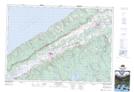
Maps showing Merrys Mill Pond, Annapolis, Nova Scotia
Merrys Mill Pond is a Lake located in Annapolis, Nova Scotia and has an elevation of 202 meters.
- Latitude: 44° 45' 21'' North (decimal: 44.7558333)
- Longitude: 65° 3' 40'' West (decimal: -65.0611111)
- Topography Feature Category: Lake
- Geographical Feature: Millpond / Mill Pond
- Canadian Province/Territory: Nova Scotia
- Elevation: 202 meters
- Location: Annapolis
- Atlas of Canada Locator Map: Merrys Mill Pond
- GPS Coordinate Locator Map: Merrys Mill Pond Lat/Long
Merrys Mill Pond NTS Map Sheets