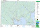
Maps showing The Mill Pond, Lunenburg, Nova Scotia
The Mill Pond is a Lake located in Lunenburg, Nova Scotia.
- Latitude: 44° 35' 11'' North (decimal: 44.5863888)
- Longitude: 64° 13' 38'' West (decimal: -64.2272222)
- Topography Feature Category: Lake
- Geographical Feature: Millpond / Mill Pond
- Canadian Province/Territory: Nova Scotia
- Location: Lunenburg
- Atlas of Canada Locator Map: The Mill Pond
- GPS Coordinate Locator Map: The Mill Pond Lat/Long
The Mill Pond NTS Map Sheets