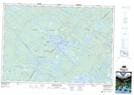
Maps showing Mudflat Lake, Annapolis, Nova Scotia
Mudflat Lake is a Lake located in Annapolis, Nova Scotia and has an elevation of 133 meters.
- Latitude: 44° 28' 17'' North (decimal: 44.4713888)
- Longitude: 65° 8' 58'' West (decimal: -65.1494444)
- Topography Feature Category: Lake
- Geographical Feature: Lake
- Canadian Province/Territory: Nova Scotia
- Elevation: 133 meters
- Location: Annapolis
- Atlas of Canada Locator Map: Mudflat Lake
- GPS Coordinate Locator Map: Mudflat Lake Lat/Long
Mudflat Lake NTS Map Sheets