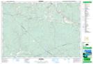
Maps showing New Lairg, Pictou, Nova Scotia
New Lairg is a Unincorporated area located in Pictou, Nova Scotia and has an elevation of 142 meters.
- Latitude: 45° 27' 16'' North (decimal: 45.4544444)
- Longitude: 62° 48' 39'' West (decimal: -62.8108333)
- Topography Feature Category: Unincorporated area
- Geographical Feature: Community
- Canadian Province/Territory: Nova Scotia
- Elevation: 142 meters
- Location: Pictou
- Atlas of Canada Locator Map: New Lairg
- GPS Coordinate Locator Map: New Lairg Lat/Long