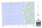
Maps showing Salmon River, Digby, Nova Scotia
Salmon River is a Unincorporated area located in Digby, Nova Scotia and has an elevation of 2 meters.
- Latitude: 44° 3' 6'' North (decimal: 44.0516666)
- Longitude: 66° 9' 39'' West (decimal: -66.1608333)
- Topography Feature Category: Unincorporated area
- Geographical Feature: Community
- Canadian Province/Territory: Nova Scotia
- Elevation: 2 meters
- Location: Digby
- Atlas of Canada Locator Map: Salmon River
- GPS Coordinate Locator Map: Salmon River Lat/Long