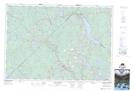
Maps showing Stanley Section, Lunenburg, Nova Scotia
Stanley Section is a Unincorporated area located in Lunenburg, Nova Scotia and has an elevation of 91 meters.
- Latitude: 44° 30' 22'' North (decimal: 44.5061111)
- Longitude: 64° 43' 31'' West (decimal: -64.7252777)
- Topography Feature Category: Unincorporated area
- Geographical Feature: Dispersed Rural Community
- Canadian Province/Territory: Nova Scotia
- Elevation: 91 meters
- Location: Lunenburg
- Atlas of Canada Locator Map: Stanley Section
- GPS Coordinate Locator Map: Stanley Section Lat/Long
Stanley Section NTS Map Sheets