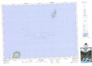
Maps showing St. Paul Island, Victoria, Nova Scotia
St. Paul Island is a Island located in Victoria, Nova Scotia and has an elevation of 71 meters.
- Latitude: 47° 12' North (decimal: 47.1999999)
- Longitude: 60° 9' West (decimal: -60.1491666)
- Topography Feature Category: Island
- Geographical Feature: Island
- Canadian Province/Territory: Nova Scotia
- Elevation: 71 meters
- Location: Victoria
- Atlas of Canada Locator Map: St. Paul Island
- GPS Coordinate Locator Map: St. Paul Island Lat/Long
St. Paul Island NTS Map Sheets