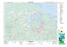
Maps showing Tanner Hill, Pictou, Nova Scotia
Tanner Hill is a Mountain located in Pictou, Nova Scotia and has an elevation of 75 meters.
- Latitude: 45° 33' North (decimal: 45.5500000)
- Longitude: 62° 50' West (decimal: -62.8325000)
- Topography Feature Category: Mountain
- Geographical Feature: Hill
- Canadian Province/Territory: Nova Scotia
- Elevation: 75 meters
- Location: Pictou
- Atlas of Canada Locator Map: Tanner Hill
- GPS Coordinate Locator Map: Tanner Hill Lat/Long