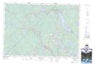
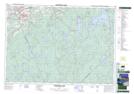
Maps showing Tanner Lake, Kings, Nova Scotia
Tanner Lake is a Lake located in Kings, Nova Scotia and has an elevation of 212 meters.
- Latitude: 44° 44' 58'' North (decimal: 44.7494444)
- Longitude: 64° 46' 52'' West (decimal: -64.7811111)
- Topography Feature Category: Lake
- Geographical Feature: Lake
- Canadian Province/Territory: Nova Scotia
- Elevation: 212 meters
- Location: Kings
- Atlas of Canada Locator Map: Tanner Lake
- GPS Coordinate Locator Map: Tanner Lake Lat/Long
Tanner Lake NTS Map Sheets