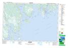
Maps showing Thrum Cap, Shelburne, Nova Scotia
Thrum Cap is a Island located in Shelburne, Nova Scotia and has an elevation of 0 meters.
- Latitude: 43° 42' North (decimal: 43.7000000)
- Longitude: 65° 10' West (decimal: -65.1658333)
- Topography Feature Category: Island
- Geographical Feature: Thrumcap / Thrum Cap
- Canadian Province/Territory: Nova Scotia
- Elevation: 0 meters
- Location: Shelburne
- Atlas of Canada Locator Map: Thrum Cap
- GPS Coordinate Locator Map: Thrum Cap Lat/Long
Thrum Cap NTS Map Sheets