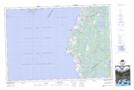
Maps showing Pointe à Tom, Digby, Nova Scotia
Pointe à Tom is a Cape located in Digby, Nova Scotia and has an elevation of 2 meters.
- Latitude: 44° 11' North (decimal: 44.1833333)
- Longitude: 66° 11' West (decimal: -66.1824999)
- Topography Feature Category: Cape
- Geographical Feature: Pointe
- Canadian Province/Territory: Nova Scotia
- Elevation: 2 meters
- Location: Digby
- Atlas of Canada Locator Map: Pointe à Tom
- GPS Coordinate Locator Map: Pointe à Tom Lat/Long