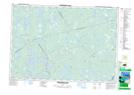
Maps showing Upper Long Falls, Digby, Nova Scotia
Upper Long Falls is a Falls located in Digby, Nova Scotia.
- Latitude: 44° 11' North (decimal: 44.1833333)
- Longitude: 65° 51' West (decimal: -65.8491666)
- Topography Feature Category: Falls
- Geographical Feature: Falls
- Canadian Province/Territory: Nova Scotia
- Location: Digby
- Atlas of Canada Locator Map: Upper Long Falls
- GPS Coordinate Locator Map: Upper Long Falls Lat/Long
Upper Long Falls NTS Map Sheets