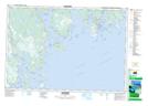
Maps showing West Port Clyde, Shelburne, Nova Scotia
West Port Clyde is a Unincorporated area located in Shelburne, Nova Scotia and has an elevation of 1 meters.
- Latitude: 43° 35' 18'' North (decimal: 43.5883333)
- Longitude: 65° 27' 25'' West (decimal: -65.4569444)
- Topography Feature Category: Unincorporated area
- Geographical Feature: Dispersed Rural Community
- Canadian Province/Territory: Nova Scotia
- Elevation: 1 meters
- Location: Shelburne
- GPS Coordinate Locator Map: West Port Clyde Lat/Long
West Port Clyde NTS Map Sheets