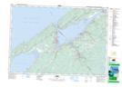
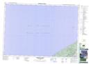
Maps showing Granville Ferry Range and Training Area, Annapolis, Nova Scotia
Granville Ferry Range and Training Area is a Military area located in Annapolis, Nova Scotia and has an elevation of 206 meters.
- Latitude: 44° 45' 35'' North (decimal: 44.7597221)
- Longitude: 65° 31' 50'' West (decimal: -65.5305555)
- Topography Feature Category: Military area
- Geographical Feature: C.F.T.A.
- Canadian Province/Territory: Nova Scotia
- Elevation: 206 meters
- Location: Annapolis
- Atlas of Canada Locator Map: Granville Ferry Range and Training Area
- GPS Coordinate Locator Map: Granville Ferry Range and Training Area Lat/Long
Granville Ferry Range and Training Area NTS Map Sheets