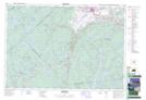
Maps showing New Russell, Lunenburg, Nova Scotia
New Russell is a Unincorporated area located in Lunenburg, Nova Scotia.
- Latitude: 44° 46' 14'' North (decimal: 44.7705555)
- Longitude: 64° 25' 25'' West (decimal: -64.4236111)
- Topography Feature Category: Unincorporated area
- Geographical Feature: Community
- Canadian Province/Territory: Nova Scotia
- Location: Lunenburg
- Atlas of Canada Locator Map: New Russell
- GPS Coordinate Locator Map: New Russell Lat/Long
New Russell NTS Map Sheets