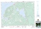
Maps showing Black Angus Pool, Inverness, Nova Scotia
Black Angus Pool is a River feature located in Inverness, Nova Scotia.
- Latitude: 46° 12' 31'' North (decimal: 46.2085998)
- Longitude: 61° 8' 51'' West (decimal: -61.1474998)
- Topography Feature Category: River feature
- Geographical Feature: Fishing Pool
- Canadian Province/Territory: Nova Scotia
- Location: Inverness
- Atlas of Canada Locator Map: Black Angus Pool
- GPS Coordinate Locator Map: Black Angus Pool Lat/Long
Black Angus Pool NTS Map Sheets